
Climate & resilience
38 Minutes on the Trishuli
A mountain came apart above a valley we had already filled with people, tunnels and turbines.
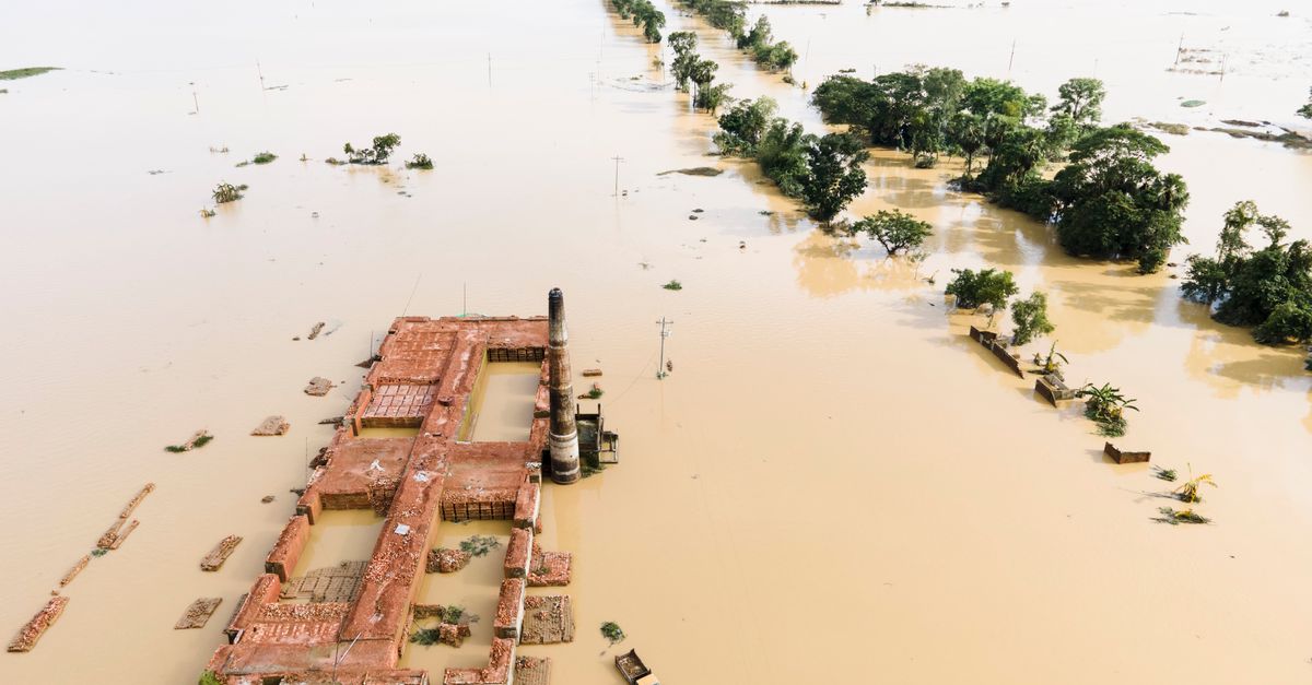
A mountain came apart above a valley we had already filled with people, tunnels and turbines. The ice was loosened by a warming climate. Almost everything else was a decision.
Environmental Solutions Limited
Published 7 September 2026 · Casualty and damage figures as of 3–6 September and still moving
At 8:37 on the morning of 26 August 2026, roughly a fifth of a square kilometre of ice and bedrock detached from the northern flank of Langtang Lirung, at about 5,200 metres above sea level, and fell some 1,200 metres into the valley below. Seismometers registered the impact as a magnitude 5.2 event. Nobody in the villages downstream knew what the shaking meant.
What came down the Lhende Khola was not water. It was a slurry of pulverised rock, ice melting from its own friction, and everything the flow could tear out of the channel as it went — moving, by later reconstruction, at something like 50 metres per second. It briefly dammed the river, ponded behind that dam, then breached it. The resulting flood ran about 100 kilometres down the Lhende and the Trishuli, through Rasuwa, Nuwakot, Dhading, Gorkha and into Chitwan, and northward into Gyirong County in Tibet.
By early September the recorded toll in Nepal stood above 1,350 dead, with close to 5,000 people still missing; Tibetan authorities reported a further 43 dead and more than 500 missing. Nearly 1.6 million people were affected in some way. Among the missing were 576 workers from a single hydropower project, roughly 300 of them believed to have been inside a tunnel when the water arrived.
It is tempting, and comfortable, to file this under acts of God. It should not be filed there. The failure high on Langtang Lirung was the trigger. The scale of what happened afterwards was built.
Part one · the mechanismThis was not the disaster we had planned for
The Himalayan flood most agencies had rehearsed is a glacial lake outburst flood: a moraine-dammed lake fails, and a known volume of water is released from a mapped, monitored basin. That framing is what most hazard inventories, most early warning designs and most engineering standards in the region are built around.
This was not that. Analysts examining the satellite record found no lake at the source. What happened was a cascade: an ice-and-rock detachment from a steep, high slope, converting to a rock–ice avalanche, bulking up with channel sediment and meltwater into a debris flow, temporarily blocking the river, and then failing as a landslide dam. Each stage handed energy to the next. The hazard that arrived at Syabrubesi bore very little resemblance to the hazard the valley’s instruments had been asked to look for.
5,000 m4,000 m3,000 m2,000 m1,000 m0.2 km² of ice and rock, ~5,200 mdetachment 08:37 — falls ~1,200 mtemporary debris damon the Lhende Khola, then breachedRasuwagadhi / Gyirong border portSyabrubesi gauge — swept away 08:50Upper Trishuli hydropower clusterChitwan lowlands, ~100 km0 km50 km downstream100 km
Schematic long profile of the 26 August cascade. Distances and elevations are approximate and drawn to show the sequence, not to survey it; the vertical scale is exaggerated. Marker times follow the Department of Hydrology and Meteorology record.Part two · the looseningWhat a warming climate did to the slope
High mountain Asia is warming considerably faster than the planet as a whole. Recent work on the Langtang glaciers records local warming of roughly 0.31 °C per decade, against a global mean rate on the order of 0.06–0.07 °C per decade. Over the same period, glacier retreat in the catchment ran about 1.5 times faster between 2000 and 2023 than it had between 1964 and 2000.
Retreat is not only a matter of ice disappearing. As glaciers thin and fragment, lower tongues detach and vanish, and what remains is left hanging on high, steep bedrock with less ice below to buttress it. At the same time, permafrost that has cemented rock and debris together for millennia begins to thaw, and additional meltwater at the base of the ice reduces the friction holding it to the rock. Warming does not push the slope. It removes, slowly and invisibly, the things that were holding the slope in place.
Honest attribution matters here, and it cuts both ways. No credible scientist has claimed that this specific collapse, on this specific morning, was caused by climate change; single-event attribution in high mountain terrain is genuinely difficult, and glaciers have shed ice onto valleys for as long as there have been glaciers. The IPCC’s position is more careful and more damning: that decline in glacier, snow and permafrost has already altered the frequency, magnitude and location of most related natural hazards, with high confidence. Glaciologists analysing Langtang have said much the same — that warming has probably increased the likelihood of an event like this one, and that we should expect more of them.
The climate signal does not tell you which slope will fail. It tells you that more slopes are now capable of failing, in places where the historical record says they did not.Part three · the amplification
Everything downstream was a choice
A rock–ice avalanche into an empty valley is a geological event. This one ran into a corridor that had been developed hard and fast, largely without asking what the mountain above it was doing.
More than thirty hydropower projects are operating or under construction in the Trishuli basin. They were permitted one at a time. Critics inside Nepal’s own energy sector have described the approvals as haphazard — granted without basin-scale planning and without assessment of the natural hazards the basin could deliver, including flood surges originating across the border in Tibet. The economist Arjun Dhakal has argued that the scale of damage to hydropower followed directly from that permitting pattern.
The financiers had the same blind spot. A cumulative impact assessment of the Trishuli basin published by the International Finance Corporation in 2020 examined environmental and social impacts across the whole basin — and did not address glacial lake outburst floods or comparable flood disasters. Lenders’ own safeguard policies require that such risks be examined. In practice, across the Himalaya, there is scarcely a documented case of a dam or hydropower licence being refused on the grounds that the site was too geologically fragile or too exposed.
Then there is what the construction itself does to a fragile valley. Tunnelling, blasting, excavation, road cuts, deforestation and the dumping of spoil into and beside river channels all destabilise slopes and load the river with material that a surge can weaponise. Build several projects in one basin and those effects compound. In the aftermath, one design lesson emerged immediately and bleakly: underground powerhouses came through far better than surface structures. That was known before 26 August. It was priced out.
And people were placed in the path. Some 8,317 houses were destroyed. Nineteen schools were destroyed outright and roughly eighty more damaged. Workers’ camps and tunnel portals sat on the floor of a channel that had carried debris flows before — a 2015 event in the same area moved several million cubic metres of ice and debris.
Part four · the warningThirty-eight minutes, and the wrong message
Nepal has sensors. What it did not have, on that morning, was a system.
08:37Collapse. Ice and bedrock detach on Langtang Lirung. The National Earthquake Monitoring Centre registers the signal but issues no public alert — the seismic frequency does not match an earthquake, and there is no protocol for what it does match.08:50The gauge dies. The Bhotekoshi river-level station at Syabrubesi is swept away. Its sensors were built to detect the gradual rise of a monsoon flood, not a debris surge travelling at highway speed.09:00The District Administration Office reaches the Department of Hydrology and Meteorology. Nobody yet knows the scale.09:15SMS alerts go out to Rasuwa, Nuwakot, Dhading and Chitwan — 38 minutes after the collapse. Generic wording, Nepali only, no specific location, no severity, no instruction to evacuate. The department has no legal authority to order one.09:42A survivor in the valley receives the message on his phone. Others report theirs arriving after the water had already passed.The upper catchment where the failure began was, in the words of one regional analyst, a monitoring blind spot — watched by neither Nepal, nor China, nor any international agency. Anil Pokhrel, formerly chief executive of Nepal’s disaster authority, put the institutional problem plainly: having sensors is not the same as having an early warning system.
What did work was human. At Tribhuvan Trishuli Secondary School, head teacher Rajendra Dawadi took phone calls from friends upstream, believed them, and moved roughly 900 students to high ground about ten minutes before the flow buried the school compound. No algorithm made that call. A trusted voice did. Researchers studying the response found the same pattern repeatedly: informal, decentralised, community-based warning outperformed the official channel, because it carried credibility and because it said what to do.
Part five · the ledgerWhat it cost
1,355confirmed dead in Nepalas of 5 Sept
4,996still missing in Nepalas of 5 Sept
43 / 519dead / missing in Gyirong, Tibetas of 6 Sept
~1.6 mpeople affectedNepal
$2.57 bnassessed damage in Nepalas of 4 Sept
$5 bnfinance ministry rebuild estimateupper bound
431 MWgeneration removed from the grid13 projects damaged
2.2 Mtof debris generatedUNDP estimate
8,317houses destroyedplus 7 health facilities
68suspension bridges damaged33 beyond repair
Nepal became a net electricity exporter in 2025. The generation lost in a single morning will likely reverse that this winter, in the low-flow season, at exactly the moment domestic demand peaks. A development strategy concentrated in one river basin has now discovered what that basin can do.
Part six · the obligationWhat responsible practice looks like from here
None of what follows would have stopped the slope from failing. All of it would have reduced the number of people the failure could reach. These are not exotic asks; most were already on the table before 26 August.
AssessCumulative risk at basin scale, including cryospheric hazardsProject-by-project environmental assessment cannot see a hazard that begins 40 kilometres upstream and crosses a border. Basin-level assessments must explicitly model rock–ice avalanche and landslide-dam-breach scenarios, not only glacial lake outburst floods and monsoon peaks.
FinanceClimate and geohazard screening as a condition of capitalLenders’ safeguard policies already require this. The 2020 Trishuli cumulative assessment shows the requirement can be satisfied on paper without the hazard ever being examined. Screening should be independently verified, and its absence should be disqualifying.
DesignBuild to the maximum credible flood, not the historical oneUnderground powerhouses, longer access tunnels, elevated and set-back camps and switchyards. Nepali engineers put the premium at roughly 10–12% of project cost — against a single event that has cost the country somewhere between $2.5 and $5 billion.
MonitorInstrument the blind spot, and share the data across the borderSlope-stability and seismic monitoring in the upper catchments, with detection logic tuned for mass-movement signatures rather than earthquakes alone. A hazard that begins in Tibet and lands in Chitwan cannot be warned about by one country’s network.
WarnCell broadcast, multiple languages, and the authority to say “leave now”Cell broadcast reaches a defined geographic zone in seconds, in several languages, and is costed for Nepal at roughly $1.75–3 million. Pair it with funded community volunteer networks — the channel that actually worked — and with binding procedures connecting a forecast to a mandatory evacuation order. A 2022 study recommended exactly that. It was never implemented.
SiteKeep people off debris-flow fansHazard-informed land-use rules for settlements, schools, health posts and worker accommodation on valley floors with a record of mass movement — enforced at permitting, not negotiated after construction.
The honest summary is this. A warming climate is steadily converting stable Himalayan slopes into unstable ones, and it will keep doing so regardless of what any single company or ministry decides this year. That part is now a given to be planned around. What remains fully within human control is how many people, tunnels, turbines and classrooms sit in the path when a slope gives way, and how much warning they get. On 26 August, in the Trishuli valley, the answers were: far too many, and thirty-eight minutes too late.
A message from Environmental Solutions Limited
Our thoughts and our prayers are with every family in Rasuwa, Nuwakot, Dhading, Gorkha and Chitwan, and with the families of Gyirong, who have lost someone to the waters of the Trishuli.
We pray for those still missing, and for the parents, children and partners who are waiting for news. We pray for the injured and the displaced, for the schoolchildren whose classrooms are gone, and for the hydropower workers and the families still standing at the mouths of those tunnels. We pray for the rescuers — the soldiers, the police, the medical teams and the neighbours who went into the mud with their hands, and who are still there.
And we pray for the communities of the Himalaya, who carry the sharpest edge of a warming world they did least to cause. May the dead rest, may the missing be found, and may those who remain be given the strength, the shelter and the support to rebuild.
We grieve with the people of Nepal and Tibet, and we hold them in our prayers.
Environmental Solutions Limited7 September 2026
A note on the figures
Casualty, damage and infrastructure figures in this article are drawn from official Nepali and Chinese reporting dated between 3 and 6 September 2026, and were still changing at the time of writing. Death and missing counts in particular have been revised repeatedly. Elevations, volumes and flow velocities for the initial failure are early estimates derived from satellite imagery and seismic records, and should be treated as provisional. Please verify current figures before republication.
Sources
- 2026 Nepal–Tibet floods — Wikipedia
- 2026 Nepal Debris Avalanche and Flash Flood — U.S. Geological Survey
- August 2026 Nepal–Tibet floods — Bethan Davies, AntarcticGlaciers.org
- Nepal floods of 2026 — Britannica
- Nepal’s flood disaster puts its hydropower-first strategy, exports to the test — Mongabay
- During Nepal floods, decentralized, community-based warning saved lives — Mongabay
- Nepal sent alert 38 minutes after glacier collapse. It wasn’t enough — Inquirer
- Flood risks to Nepal hydropower project were known – but banks ignored them — Scroll.in
- Nepal–Tibet floods: what is a glacial collapse, how common is it? — Al Jazeera
- Nepal Floods 2026 — UNDP
- Early warning could have saved hundreds of lives in Nepal floods — Nature India